| |
The Lands Department (LandsD) is the central authority for positioning infrastructure, land surveys and all types of mapping in Hong Kong. The Survey and Mapping Office (SMO) of LandsD maintains a comprehensive set of maps—of different scales in hard copy and digital form—for a wide variety of applications by the community. Besides, it also maintains the positioning infrastructure, and develops and provides handy web-map services to users across government bureaux/departments (B/Ds) as well as the general public. With its expertise in Geographic Information System (GIS), LandsD has been consolidating and disseminating its map products and various spatially enabled data to both the Government and the community for decades. This article details LandsD’s latest development in positioning infrastructure and web map services in connection with the smart city initiatives.
Positioning infrastructure
In many smart city applications, it is essential to have access to rich access to and useful spatial information as well as being able to accurately, quickly and efficiently obtain location information. As the fundamental horizontal and vertical positioning infrastructure, LandsD has been responsible for maintaining and enriching a network of accurate survey control points that covers the whole territory of the Hong Kong Special Administrative Region. The Hong Kong Satellite Positioning Reference Station Network (SatRef) of LandsD has been established since 2010 to support high-accuracy satellite positioning for various geospatial applications across Hong Kong.
The SatRef network consists of 18 Continuously Operating Reference Stations (CORS) including 16 reference stations and two Integrity Monitoring stations evenly distributed across the whole Hong Kong territory. The network provides a link between the local and global positioning reference systems. Under the link, spatial information in different reference frames can be effectively exchanged using the same spatial language. The SatRef provides more accurate, efficient and productive positioning services to users, with lower operational cost. It now serves as a core component of the modern positioning infrastructure in Hong Kong.
|
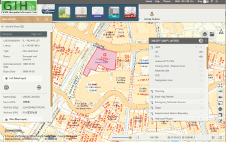
| New GIH 3.0 adopts modular architecture—enhancing spatial data content and analysis functions, e.g. the 3DExplorer module. |
Ubiquitous positioning, i.e. accurate, seamless and real-time positioning anytime and anywhere, is essential to support smart city initiatives. It could not be achieved without a comprehensive and smart positioning infrastructure. LandsD will continue to explore advanced positioning and Internet of Things (IoT) technologies to leverage the full potential of Hong Kong’s positioning infrastructure. The new IoT positioning technologies may open up new business opportunities for innovative applications and facilitate greater market participation, providing value-added products and services that contributes to the economic development of Hong Kong.
Geospatial Information Hub (GIH 3.0)
On the basis of its expertise in the collection, collation, analysis, distribution and management of geospatial data and the setting up and applications of the GIS, LandsD launched the HKSAR Geospatial Information Hub (GIH) in 2004. Through the GIH, geospatial data and related information collected from various departments can be effectively distributed and shared across the whole government.
The new GIH 3.0 was officially launched in January 2019 to succeed GIH 2.0, which was released in 2008, with a view to providing a new information-sharing portal with continuous enhancement in spatial data content and its functionality.
|
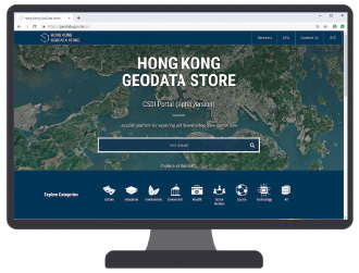
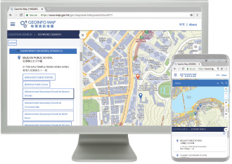
| Hong Kong GeoData Store—the alpha version of CSDI portal which enhances sharing and accessibility of geo-tagged information—aims to facilitate innovative and value-added reuse by application developers, academia and the public. |
LandsD has been collaborating with different B/Ds in making GIH an ideal platform for disseminating geospatial information with the aim of delivering better public services. For example, the Food and Environmental Hygiene Department (FEHD) has released the Dengue Fever Ovitrap Index and Dengue Fever Case information to different government departments via the GIH and established an effective data updating mechanism with LandsD since 2005.
Advanced functions in the GIH, including spatial analysis and trend display functions, have been developed by LandsD to facilitate efficient visualisation and retrieval of ovitrap survey summaries by FEHD and other government departments. By sharing information and the spatial analysis results via an interactive map interface, relevant government departments could provide swift responses in pest control actions. This is one of several good examples of cross-departmental partnership facilitating the delivery of better public services.
Hong Kong GeoData Store
Because of increasing spatial awareness and public’s need for open spatial data, LandsD has developed and launched the Hong Kong GeoData Store (GeoData Store) (https://geodata.gov.hk) in December 2018, serving as the alpha version for the CSDI portal, an open spatial data initiative to facilitate the sharing of geospatial data. It supports various smart city initiatives and applications through the innovative use of geospatial data and information technology. Through this portal, users can explore different geospatial datasets provided by various government departments and non-governmental organisations, including government premises/facilities, schools, hospitals, clinics, community and social services facilities, cultural, leisure and sports facilities, postal services facilities and job centres. The portal also provides a user-friendly map interface to enable users to easily browse and understand various geospatial datasets.
In its maiden launch, the GeoData Store has converted 79 types of public facility geospatial data sourced from government departments and made
them available as open and machine-readable formats (GeoJSON, GML, KML and CSV) together with an Application Programming Interface (API) to facilitate free download and use by the public.
The GeoData Store is also equipped with other useful API services, including “Location Search API”, “Search Nearby API” and “Identity API” to support innovative map applications by developers, saving time and cost for developing applications. |
|
|
|
LandsD has also opened up various geotagged land-related data in 2019 (including “Vacant Government Sites Available for Application for Greening or Government/Institution/Community Uses”, “Short Term Tenancy” and “Provision of Open Space Required under Lease for the Use by the Public in Private Developments Completed in or after 1980”, etc. in open, machine-readable format (GML)) for free download and use by the public, facilitating land researches and analysis. Looking forward, LandsD will continue to collaborate with government departments and various public and private organisations to progressively introduce more open spatial datasets on the GeoData Store to support value-added reuse, innovations, research and analysis, and provide the necessary infrastructure and conditions for smart city applications. For example, LandsD and the Urban Renewal Authority (URA) recently worked together to publish two additional open spatial datasets on the GeoData Store, namely “Project Development Information of Completed URA Redevelopment Projects” and “URA Building Rehabilitation Projects Cost Reference”.
Map Application Programming Interface
In December 2018, LandsD also officially launched a new map service to B/Ds, namely the Map Application Programming Interface (Map API) (https://api.portal.hkmapservice.gov.hk/). This new Map API service enhances the existing LandsD’s services in providing spatial data to government departments. Government departments will now be able to embed LandsD’s maps in both their Intranet and Internet applications instead of the traditional approach of updating raw digital map data by themselves, hence largely reducing the time and effort in building and maintaining their in-house map-related applications.
|
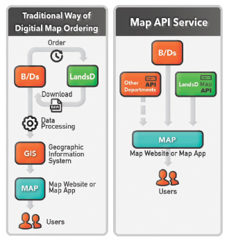
| Traditional way of raw digital map data updating and new Map API approach. |
The Map API service also provides a unified map presentation and up-to-date spatial information for government departments’ information technology/GIS systems and websites. In the past, they had to spend extra effort regularly collecting, converting and integrating LandsD’s raw spatial data into their own applications. With the Map API, these recurrent data updating maintenance processes can be significantly reduced. Currently, 21 government websites have adopted this Map API service to make their data spatial-enabled systems up-to-date. A similar Map API service was soft launched to the public in October 2019, allowing software developers to directly use government-provided map services in their map-related applications.
|
| “Visit Hong Kong” website by Tourism Commission adopts LandsD’s Map API services. |
GeoInfo Map
The GeoInfo Map (www.map.gov.hk) is a web map service launched by LandsD in May 2010 under a collaboration project with the Office of the Government Chief Information Officer (OGCIO). It provides free and convenient public access to accurate maps of Hong Kong, as well as the locations and related information about various public facilities and services. Since its launch, LandsD has been working closely with 29 government departments for the delivery of up-to-date map services and geospatial data to the public. The geospatial data provided through the GeoInfo Map has also been enhanced from 120 to 270 types of public facilities.
The revamped GeoInfo Map, launched in December 2018, strives to provide better quality web map services to the public and greater support to the GovHK portal (www.gov.hk). It enables government departments to release to the public their latest geospatial data (updated weekly) with enhanced system performance and user experience. The public can conveniently access digital maps using various platforms, including tablet computers and smartphones, as well as integrating various geospatial data for different applications.
|
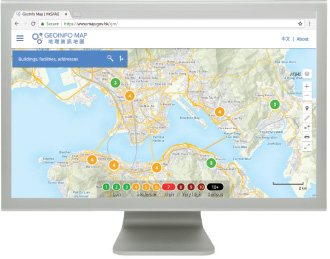
| Revamped GeoInfo Map adopts responsive web design—providing a smoother user experience for web map browsing and geospatial information discovery. |
The new GeoInfo Map provides useful map tools and an enhanced location search engine that supports various search modes to improve user-friendliness and search efficiency. Its latest map interface enables users to search for various types of real-time information including weather, traffic, air and beach water quality. The newly introduced “Geo-hashtag” feature makes it easier for users to explore and obtain location information. To enhance browsing on tablet computers and smartphones, responsive web design has been introduced to automatically adapt to the device in use for a smoother user experience.
LandsD will also explore ways to upgrade the current GeoInfo Map into a 3D digital map progressively to further enhance map and geospatial information services.
|
| Real-time data relating to weather, traffic, air and beach water quality on the revamped GeoInfo Map. |
Future development
The Hong Kong Smart City Blueprint, announced by the Government in late 2017, put forward the strategy to encourage the use of open data for smart city innovations and to develop the CSDI as a smart city infrastructure—so as to facilitate the sharing of geospatial data and support various smart city applications requiring geospatial data.
In future, LandsD will continue developing new geospatial datasets related to the city’s built environment and facilities, such as detailed 3D city models, as well as improving access to various open data of public services through the GeoData Store in both machine-readable downloadable data and APIs. LandsD will also enrich the coverage and content of the CSDI, allowing various industries to make better use of spatial data in supporting smart city development, realising the vision of the Hong Kong Smart City Blueprint. B/Ds are welcome to approach LandsD for collaboration on geo-enabling the data and/or implementing initiatives to provide geospatial-related applications that better serve both the Government and the community. |
|